Setting GeoPolitical Boundaries 1.0 ...

The Caribbean island of Saint Martin/Sint Maarten is the smallest parcel of land on Earth shared by two countries. It is half French, half Dutch, or at least roughly. Frankly, the French got the bigger "half." Why is this? According to Wikipedia it goes like this...
France and the Netherlands agreed to divide the island on March 23, 1648. Two walkers were chosen, one by the French and the other by the Dutch. The men were stood back to back at one point on the western shore of the island. They were instructed to walk (no running!) the circumference of the island in opposite directions. The point where they eventually met on the eastern side of the island was set as the other point, and the thus the frontier line was drawn, dividing Saint Martin from Sint Maarten. Seemingly, the French walker walked more than the Dutch walker. (54km as opposed to 32km). Some say the French walker was stimulated with wine, while the Dutch walker was stimulated with beer. Some say the wine consumption yielded the larger territory, while some people (from the Dutch side) suspect the French walker was actually more of a runner.
So there you have it: either the Saint Martin French are conniving, speed-demon winos or the Sint Maarten Dutch are gullible, slow-poke beer-swillers. Which is true? You'll just have to visit the island with a pal and "walk" it yourself...
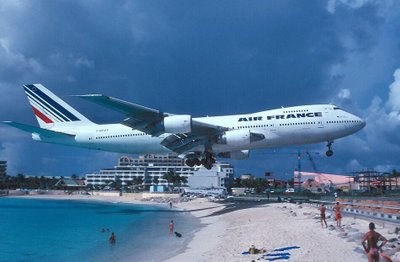
Oh and... in case you were hoping for a relaxing beach getaway... the picture is real. St. Martin has one of the world's shortest runways making these ultra-low landings necessary.

0 Comments:
Post a Comment
<< Home